


![[The AI Show Episode 143]: ChatGPT Revenue Surge, New AGI Timelines, Amazon’s AI Agent, Claude for Education, Model Context Protocol & LLMs Pass the Turing Test](https://www.marketingaiinstitute.com/hubfs/ep%20143%20cover.png)


.png?#)


.webp?#)
.webp?#)


![[Fixed] Gemini app is failing to generate Audio Overviews](https://i0.wp.com/9to5google.com/wp-content/uploads/sites/4/2025/03/Gemini-Audio-Overview-cover.jpg?resize=1200%2C628&quality=82&strip=all&ssl=1)

![What’s new in Android’s April 2025 Google System Updates [U: 4/14]](https://i0.wp.com/9to5google.com/wp-content/uploads/sites/4/2025/01/google-play-services-3.jpg?resize=1200%2C628&quality=82&strip=all&ssl=1)


![Apple Seeds tvOS 18.5 Beta 2 to Developers [Download]](https://www.iclarified.com/images/news/97011/97011/97011-640.jpg)
![Apple Releases macOS Sequoia 15.5 Beta 2 to Developers [Download]](https://www.iclarified.com/images/news/97014/97014/97014-640.jpg)


Vibe Coding 4,379 Uber Rides Into a Living Map
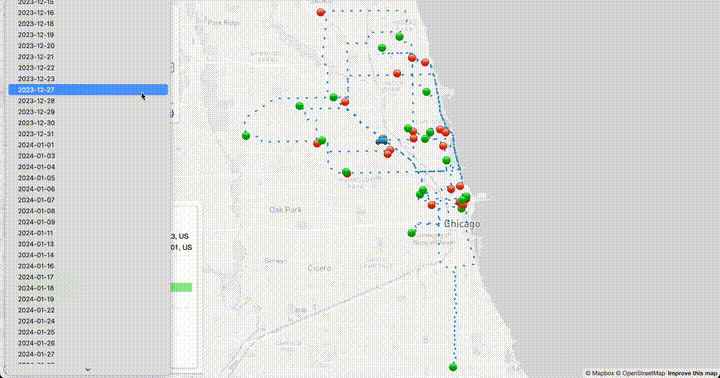
Introduction Have you ever seen a product in your mind's eye but been unsure of how to create it? Imagine you’re a full-time Uber driver. What if you could watch every mile of your Uber driving history come to life on a map? In 2023 and 2024 I drove a total of 4379 Uber rides, and I was able to scrape the Uber Drivers page to get this data (see how I did this here). I invested countless hours in this work, exploring Chicago's neighborhoods and meeting so many interesting people, and I didn't want this experience to be relegated to a CSV. I wanted a living visual (built using what I now understand is called vibe coding: creative, exploratory programming powered by AI assistance). I envisioned an animated map showing all the trips I took and how I moved between them. This was something I could show to my family and friends, explaining to them where I went better than raw data or mere numbers. More importantly, it would help jog my memory of my myriad experiences. I just didn't have much experience in web animation or GIS, and I balked when I thought of the time investment and frustrations along the way to get to what I wanted. TL;DR: I scraped 4379 Uber rides, geocoded the routes, and used AI-assisted vibe coding with ChatGPT to build an animated map of every trip — day by day — using Python, Mapbox, and GeoJSON. Here it is! The Vibe Coding Process Thankfully, now with the power of code-aware LLMs, it's possible to get mostly functional examples of code based on plain English descriptions and be able to iterate through versions with the LLM. In this article I specifically used ChatGPT, with a combination of their o3-mini-high (more code-correct) and ChatGPT 4o models. My development process was roughly {LLM: initial prompt} -> {manual tweaking} -> {LLM: code tweaking, feature adding, debugging} -> {manual tweaking} .... In this article I'll show you the power of using LLMs and vibe coding in conjunction with language fluency (in this project, Python and JavaScript) to bring an idea to life. When facing domains I didn't have a lot of experience in (GIS and web animation), and being a learner more from examples than reference, it was extremely helpful to get examples of semi-working code from the LLM and then be able to learn concepts backwards. Even this article is somewhat vibe-coded. I gave ChatGPT a prompt that it's an award-winning and viral writing coach and asked it for a narrative structure and a number of catchy titles. It broadly outlined the article and I iterated with it to find the title that was most "me". The prose in the body of this article is all me, but the skeleton was aided considerably by AI. I used it as well to analyze my language and point out potential readability issues in my language, considering my audience of fellow coders and hiring managers for the kinds of roles I want. The Challenge Having the intuitive sense that an animation of all 4379 rides at once would be spaghetti on the map and unintelligible, I realized I'd want to show my Uber driving day-by-day. Since I often drove late into the night for people going out, I had to unconventionally set my "day" to 5:00 AM - 4:59 AM the next day. I also knew that the addresses in my data were non-specific: In [1]: import pandas as pd In [2]: rides = pd.read_csv('../../data/rides.csv') In [3]: rides['pickup_address'].head() Out[3]: 0 N Ashland Ave, Chicago, IL 60614-1105, US 1 N Lincoln Ave, Chicago, IL 60613, US 2 N Clifton Ave, Chicago, IL 60657-2224, US 3 W Belmont Ave, Chicago, IL 60657-4511, US 4 N Whipple St, Chicago, IL 60647-3821, US Name: pickup_address, dtype: object I would need a robust geocoding service that could handle these locations. The geocoding would result in (latitude, longitude) coordinates for each pickup_address and dropoff_address. I also didn't want to just draw lines between these coordinates, which would ignore real streets. So I needed a routing API to give me street-based paths based on two lat/long coordinates. From these routes, I would then want to display them on a live map on the web. I knew I needed a third API to show a map overlaid with markers and paths. I just didn't know what format of data this would require. Solution Exploration with ChatGPT Through talking to ChatGPT, I was able to learn a lot more about GIS, specifically that these paths would be called geometries and that I could store these as GeoJSON files which would then be usable in a live map. Here's a prompt I used to start to get familiar with the technology out there: I have a list of locations with zip code and sometimes a street name, but no specific house numbers. They are time stamped. I want to build an animation of movement between these points in a car, using roads that one would take between those locations using routing software like Google Maps. How could I do this? Alternately, how could I generate the GPX file so
Introduction
Have you ever seen a product in your mind's eye but been unsure of how to create it?
Imagine you’re a full-time Uber driver. What if you could watch every mile of your Uber driving history come to life on a map?
In 2023 and 2024 I drove a total of 4379 Uber rides, and I was able to scrape the Uber Drivers page to get this data (see how I did this here). I invested countless hours in this work, exploring Chicago's neighborhoods and meeting so many interesting people, and I didn't want this experience to be relegated to a CSV. I wanted a living visual (built using what I now understand is called vibe coding: creative, exploratory programming powered by AI assistance).
I envisioned an animated map showing all the trips I took and how I moved between them. This was something I could show to my family and friends, explaining to them where I went better than raw data or mere numbers. More importantly, it would help jog my memory of my myriad experiences.
I just didn't have much experience in web animation or GIS, and I balked when I thought of the time investment and frustrations along the way to get to what I wanted.
TL;DR:
I scraped 4379 Uber rides, geocoded the routes, and used AI-assisted vibe coding with ChatGPT to build an animated map of every trip — day by day — using Python, Mapbox, and GeoJSON. Here it is!
The Vibe Coding Process
Thankfully, now with the power of code-aware LLMs, it's possible to get mostly functional examples of code based on plain English descriptions and be able to iterate through versions with the LLM. In this article I specifically used ChatGPT, with a combination of their o3-mini-high (more code-correct) and ChatGPT 4o models. My development process was roughly {LLM: initial prompt} -> {manual tweaking} -> {LLM: code tweaking, feature adding, debugging} -> {manual tweaking} ....
In this article I'll show you the power of using LLMs and vibe coding in conjunction with language fluency (in this project, Python and JavaScript) to bring an idea to life. When facing domains I didn't have a lot of experience in (GIS and web animation), and being a learner more from examples than reference, it was extremely helpful to get examples of semi-working code from the LLM and then be able to learn concepts backwards.
Even this article is somewhat vibe-coded. I gave ChatGPT a prompt that it's an award-winning and viral writing coach and asked it for a narrative structure and a number of catchy titles. It broadly outlined the article and I iterated with it to find the title that was most "me". The prose in the body of this article is all me, but the skeleton was aided considerably by AI. I used it as well to analyze my language and point out potential readability issues in my language, considering my audience of fellow coders and hiring managers for the kinds of roles I want.
The Challenge
Having the intuitive sense that an animation of all 4379 rides at once would be spaghetti on the map and unintelligible, I realized I'd want to show my Uber driving day-by-day. Since I often drove late into the night for people going out, I had to unconventionally set my "day" to 5:00 AM - 4:59 AM the next day.
I also knew that the addresses in my data were non-specific:
In [1]: import pandas as pd
In [2]: rides = pd.read_csv('../../data/rides.csv')
In [3]: rides['pickup_address'].head()
Out[3]:
0    N Ashland Ave, Chicago, IL 60614-1105, US
1         N Lincoln Ave, Chicago, IL 60613, US
2    N Clifton Ave, Chicago, IL 60657-2224, US
3    W Belmont Ave, Chicago, IL 60657-4511, US
4     N Whipple St, Chicago, IL 60647-3821, US
Name: pickup_address, dtype: object
I would need a robust geocoding service that could handle these locations. The geocoding would result in (latitude, longitude) coordinates for each pickup_address and dropoff_address.
I also didn't want to just draw lines between these coordinates, which would ignore real streets. So I needed a routing API to give me street-based paths based on two lat/long coordinates.
From these routes, I would then want to display them on a live map on the web. I knew I needed a third API to show a map overlaid with markers and paths. I just didn't know what format of data this would require.
Solution Exploration with ChatGPT
Through talking to ChatGPT, I was able to learn a lot more about GIS, specifically that these paths would be called geometries and that I could store these as GeoJSON files which would then be usable in a live map.
Here's a prompt I used to start to get familiar with the technology out there:
I have a list of locations with zip code and sometimes a street name, but no specific house numbers. They are time stamped. I want to build an animation of movement between these points in a car, using roads that one would take between those locations using routing software like Google Maps.

How could I do this?

Alternately, how could I generate the GPX file so I could use it with third party software?
I had learned about GPX files from some map animation apps I'd explored, which had paid tiers. I thought if I couldn't find a way to do it myself, then I could at least get the files and feed them to the external service. I found out in this line of questioning, however, that I wouldn't need an external service and that GeoJSON would be more suitable for my task.
I then asked it these clarifying questions:
Explain the difference between the Leaflet and Mapbox GL JS options
I definitely want to use Mapbox GL JS. I might break up animation on a day by day basis in which case there’d be a maximum of 50 locations per day. But I might also want to animate the entire data set which is then 4300 locations
It gave me a full breakdown of how I could do this with all three APIs I was looking for coming from Mapbox. Now I was concerned about cost, because I'm on a very limited budget for this personal project:
What is the cost of the Mapbox directions API for route finding? Give me recommendations with price comparisons on getting road routing information given my data set is 4300 points.
Thankfully, it told me that Mapbox has a free tier which allows for 100K queries in a month. It showed me a few other services, but Mapbox was clearly the winner with a cohesive set of APIs and beautiful map tiles. It offered:
What I’d Do in Your Shoes

Start with Mapbox: You’re under the 100,000 req/month and using Mapbox GL JS.

Throttle batch calls and cache results as GeoJSON to avoid repeated API hits.

If you exceed quota later, move to ORS or self-host OSRM.

Want a script to:

Cache route requests to disk as GeoJSON or GPX?

Automatically throttle and deduplicate?

Let me know — I can write that out for you.
I told it "Yes". Here we go!
Step 1: Geocoding and Routing with Mapbox
ChatGPT provided me an overview of the work it was going to do, enlightening me to details I hadn't even thought to ask, and it gave me some clarifying questions so it could work better:
Awesome. Here's what I’ll provide:

1. A **Python script** that:
- Reads your list of 4300+ locations.
- Sends route requests to **Mapbox Directions API** (or OpenRouteService).
- **Throttles** requests to stay within rate limits.
- **Caches** all responses locally (as GeoJSON) to avoid repeat API calls.
- Optionally writes a combined **GPX** or **GeoJSON** route file for animation or import.

2. Modular design so you can easily switch routing backends (Mapbox or ORS).

---

### **Questions Before I Start**

To make this precise for you, please confirm the following:

1. **Format of your input**:
- Is it a CSV file?
- What columns does it have? (e.g., `timestamp`, `zip`, `street`, `lat`, `lon`, etc.)

2. Do you already have **latitude/longitude**, or do I need to **geocode** from zip/street?

3. Which routing backend would you like to start with?
- **Mapbox Directions API**
- **OpenRouteService (ORS)**
- (We can swap easily later.)

4. Do you want the output to be:
- One long GPX file?
- One file per day?
- Both?

Once I have those answers, I’ll write your script.
I told it:
Input is a CSV file. It has columns address, zip, timestamp. You need to geocode from address ideally or fall back to zip if that doesn’t work or if results are ambiguous. Start with Mapbox Directions API. Both outputs.
It asked for a sample of my data, so I uploaded my entire 796 KB rides.csv file. I had to provide clarifying prompts subsequently for some pertinent details:
- The start address was in the
pickup_addresscolumn and the end address was in thedropoff_addresscolumn. - I wanted a route between the end address of one ride to the start address of the next ride.
- The ZIP was actually in the address fields already so it could ignore the
zipcolumn. - I didn't need GPX output after all and it could just generate GeoJSON.
- I didn't need a combined GeoJSON file of all routes, I just wanted them broken out by day.
- I wanted to filter out any rides where the geocoded address was more than 100 miles from the center of Chicago (some addresses were so generic that they geocoded to Montana).
- It kept trying to run the Python code in chat session (!!) so I told it I wanted a script I could run locally.
- That a day would end at 5 AM instead of midnight.
- I wanted to add metadata to each feature (an individual route between points within the resulting GeoJSON file) from
rides.csv, particularly whether it was an actual ride or a transition between rides. - I wanted debugging information displayed to the console so I could see progress of the script.
- I wanted it to bake in retries of the API endpoints with waits in case there were network problems.
Based on the example it provided of adding metadata to the GeoJSON features, I added in my own code to add additional metadata to ride features from rides.csv including timestamp, ride_start, ride_end, ride_type, pickup_address, dropoff_address, base_pay, surge, tip, earnings, duration, and distance.
I created a Mapbox account, created a private key for doing these requests to the Mapbox Geocoding v5 API and Mapbox Directions v5 API, stored that locally in a .env file, and loaded that with the python-dotenv library.
Amazingly, this script worked on first run!
import pandas as pd
import hashlib
import requests
import time
import json
import os
from pathlib import Path
from collections import defaultdict
import math
from dotenv import load_dotenv

load_dotenv()

MAPBOX_TOKEN = os.getenv('MAPBOX_TOKEN')
INPUT_CSV = "../../data/rides.csv"
CACHE_FILE = "cache.json"
OUTPUT_DIR = "output/geojson"
GEOCODE_BASE = "https://api.mapbox.com/geocoding/v5/mapbox.places/"
DIRECTIONS_BASE = "https://api.mapbox.com/directions/v5/mapbox/driving/"
MAX_RETRIES = 3
RETRY_DELAY = 2

CHICAGO_LAT = 41.8781
CHICAGO_LON = -87.6298
MAX_MILES = 100

# Initialize cache
Path(OUTPUT_DIR).mkdir(parents=True, exist_ok=True)
if os.path.exists(CACHE_FILE):
    with open(CACHE_FILE) as f:
        cache = json.load(f)
else:
    cache = {}

def save_cache():
    with open(CACHE_FILE, "w") as f:
        json.dump(cache, f)

def cache_key(*args):
    return hashlib.md5("::".join(args).encode()).hexdigest()

def haversine(lat1, lon1, lat2, lon2):
    R = 3958.8  # miles
    phi1, phi2 = math.radians(lat1), math.radians(lat2)
    d_phi = phi2 - phi1
    d_lambda = math.radians(lon2 - lon1)
    a = math.sin(d_phi / 2) ** 2 + math.cos(phi1) * math.cos(phi2) * math.sin(d_lambda / 2) ** 2
    return 2 * R * math.asin(math.sqrt(a))

def is_valid_point(lat, lon):
    return haversine(lat, lon, CHICAGO_LAT, CHICAGO_LON) <= MAX_MILES

def safe_request(url):
    for attempt in range(MAX_RETRIES):
        try:
            r = requests.get(url)
            if r.status_code == 200:
                return r.json()
            print(f"[HTTP {r.status_code}] {url}")
        except Exception as e:
            print(f"[Request Failed] {e}")
        time.sleep(RETRY_DELAY)
    return None

def geocode(address):
    print(f"[GEOCODE] {address}")
    key = cache_key("geocode", address)
    if key in cache:
        return cache[key]
    url = f"{GEOCODE_BASE}{requests.utils.quote(address)}.json?access_token={MAPBOX_TOKEN}&limit=1"
    data = safe_request(url)
    coords = None
    if data and data.get("features"):
        coords = data["features"][0]["geometry"]["coordinates"]
        # Filter out-of-bounds geocoded results
        if not is_valid_point(coords[1], coords[0]):
            print(f"[SKIPPED] Geocoded point {coords} too far from Chicago")
            coords = None
    cache[key] = coords
    return coords

def route_between(c1, c2):
    if not is_valid_point(c1[1], c1[0]) or not is_valid_point(c2[1], c2[0]):
        print(f"[SKIPPED] One or both points out of range: {c1}, {c2}")
        return None

    print(f"[ROUTE] {c1} -> {c2}")
    key = cache_key("route", str(c1), str(c2))
    if key in cache:
        return cache[key]

    coords_str = f"{c1[0]},{c1[1]};{c2[0]},{c2[1]}"
    url = f"{DIRECTIONS_BASE}{coords_str}?access_token={MAPBOX_TOKEN}&geometries=geojson"
    data = safe_request(url)

    geometry = None
    if data and data.get("routes"):
        route = data["routes"][0]["geometry"]
        coords = route.get("coordinates", [])
        coords = [pt for pt in coords if is_valid_point(pt[1], pt[0])]
        if coords:
            route["coordinates"] = coords
            geometry = route
        else:
            print("[SKIPPED] All route points filtered out as outliers")

    cache[key] = geometry
    return geometry

def save_geojson(day, features):
    geojson = {
        "type": "FeatureCollection",
        "features": features
    }
    out_path = os.path.join(OUTPUT_DIR, f"{day}.geojson")
    with open(out_path, "w") as f:
        json.dump(geojson, f)
    print(f"[SAVED] {out_path}")

rides_df = pd.read_csv(INPUT_CSV)
rides_df["ride_start"] = pd.to_datetime(rides_df["ride_start"])
rides_df = rides_df.sort_values("ride_start")

# Geocode pickup and dropoff
rides_df["pickup_coords"] = rides_df["pickup_address"].apply(geocode)
rides_df["dropoff_coords"] = rides_df["dropoff_address"].apply(geocode)
rides_df = rides_df[rides_df["pickup_coords"].notnull() & rides_df["dropoff_coords"].notnull()]

routes_by_day = defaultdict(list)

for i in range(len(rides_df)):
    ride = rides_df.iloc[i]
    ride_time = ride["ride_start"]
    if ride_time.time() < pd.to_datetime("05:00").time():
        day = (ride_time - pd.Timedelta(days=1)).date()
    else:
        day = ride_time.date()

    # 1. pickup -> dropoff
    geometry1 = route_between(ride["pickup_coords"], ride["dropoff_coords"])
    if geometry1:
        routes_by_day[day].append({
            "type": "Feature",
            "geometry": geometry1,
            "properties": {
                "timestamp": ride["ride_start"].isoformat(),
                "type": "ride",
                "rideType": ride["ride_type"],
                "pickupAddress": ride["pickup_address"],
                "dropoffAddress": ride["dropoff_address"],
                "basePay": f"{float(ride['base_pay']):.2f}",
                "surge": f"{float(ride['surge']):.2f}",
                "tip": f"{float(ride['tip']):.2f}",
                "earnings": f"{float(ride['earnings']):.2f}",
                "duration": f"{int(ride['duration'])}",
                "distance": f"{float(ride['distance']):.2f}",
                "rideStartTime": ride['ride_start'].strftime("%B %d, %Y at %I:%M %p"),
                "rideEndTime": pd.to_datetime(ride['ride_end']).strftime("%B %d, %Y at %I:%M %p")
            }
        })

    # 2. dropoff -> next pickup (if available)
    if i < len(rides_df) - 1:
        next_ride = rides_df.iloc[i + 1]
        geometry2 = route_between(ride["dropoff_coords"], next_ride["pickup_coords"])
        if geometry2:
            routes_by_day[day].append({
                "type": "Feature",
                "geometry": geometry2,
                "properties": {
                    "timestamp": next_ride["ride_start"].isoformat(),
                    "type": "transition"
                }
            })

for day, features in routes_by_day.items():
    save_geojson(str(day), features)

save_cache()
print("✅ Done generating cleaned route files.")
Voila! Now I had 339 individual daily GeoJSON files in my output/geojson folder.
Step 2: Building Interactive Map with Mapbox GL JS and Turf.js
All of these files won't do me much good unless I can visualize them. I don't want to replicate the full set of iterations of prompts I gave ChatGPT to generate this, because this was hundreds of prompts over several days. The steps were a variety of:
- I tried AI-assisted tweaks that didn't work out the way I wanted,
- went back to previous versions,
- sent my manually tweaked code to ChatGPT to update its memory,
- pasted in errors from the browser's dev console to debug them,
- did considerable additions to the code myself after I learned how it all worked by example.
I also had to write my own script to produce the static array of GeoJSON file paths in the file days.js, since I knew I'd be hosting this on Github Pages and I wasn't sure if the client-side script would be able to access an index listing of the output/geojson file.
Instead, let me offer you a reverse-generated prompt. I gave ChatGPT the final HTML/JS code and asked it:
This is the actual HTML/JS produced, make a prompt that would generate this. Tailor this for use with ChatGPT AI using specifically the o3-mini-high model. Give me the prompt in a format I can easily copy and paste to use in a Markdown document.
The prompt it gave me, which I think describes the project well, is:
Prompt for ChatGPT (o3-mini-high): Route Animation Web App
Build a complete
index.htmlfile that displays an animated driving route using Mapbox GL JS. The animation should read from a local GeoJSON file per day and animate a car marker driving the route point-by-point.