


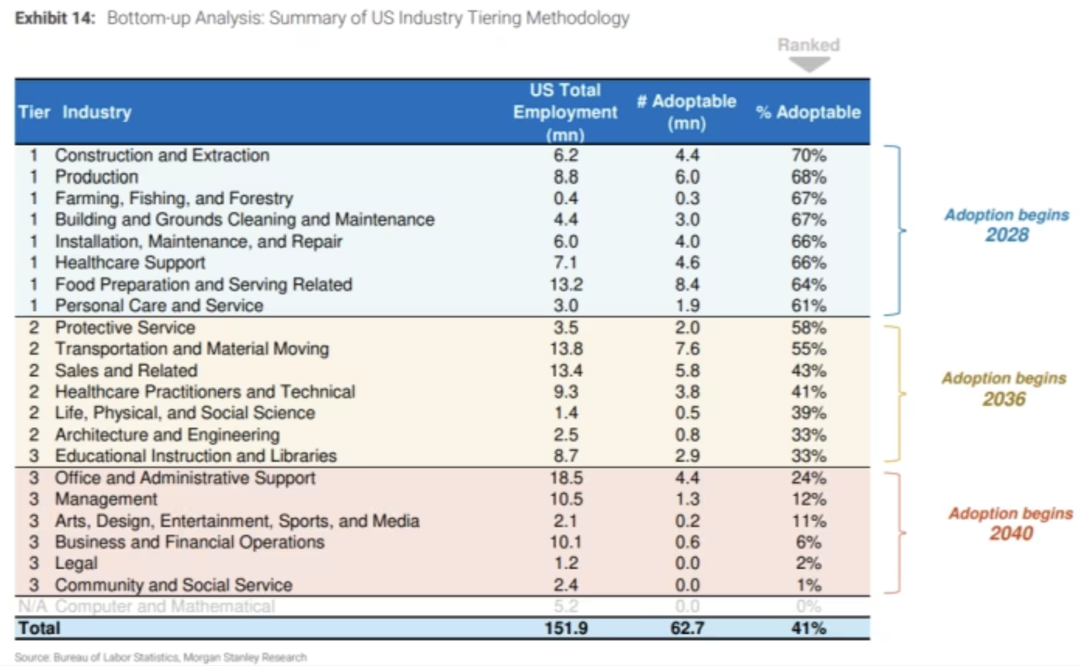


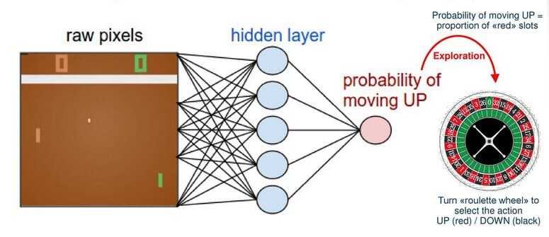
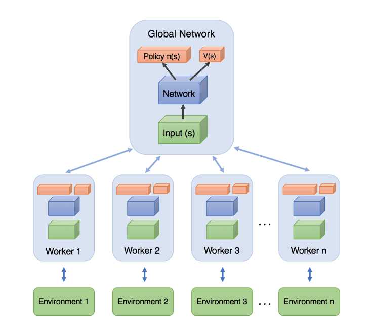
![[The AI Show Episode 145]: OpenAI Releases o3 and o4-mini, AI Is Causing “Quiet Layoffs,” Executive Order on Youth AI Education & GPT-4o’s Controversial Update](https://www.marketingaiinstitute.com/hubfs/ep%20145%20cover.png)


![Re-designing a Git/development workflow with best practices [closed]](https://i.postimg.cc/tRvBYcrt/branching-example.jpg)


![From Art School Drop-out to Microsoft Engineer with Shashi Lo [Podcast #170]](https://cdn.hashnode.com/res/hashnode/image/upload/v1746203291209/439bf16b-c820-4fe8-b69e-94d80533b2df.png?#)


(1).jpg?#)


![What Google Messages features are rolling out [May 2025]](https://i0.wp.com/9to5google.com/wp-content/uploads/sites/4/2023/12/google-messages-name-cover.png?resize=1200%2C628&quality=82&strip=all&ssl=1)


_Inge_Johnsson-Alamy.jpg?width=1280&auto=webp&quality=80&disable=upscale#)


![New Apple iPad mini 7 On Sale for $399! [Lowest Price Ever]](https://www.iclarified.com/images/news/96096/96096/96096-640.jpg)
![Apple to Split iPhone Launches Across Fall and Spring in Major Shakeup [Report]](https://www.iclarified.com/images/news/97211/97211/97211-640.jpg)
![Apple to Move Camera to Top Left, Hide Face ID Under Display in iPhone 18 Pro Redesign [Report]](https://www.iclarified.com/images/news/97212/97212/97212-640.jpg)
![Apple Developing Battery Case for iPhone 17 Air Amid Battery Life Concerns [Report]](https://www.iclarified.com/images/news/97208/97208/97208-640.jpg)


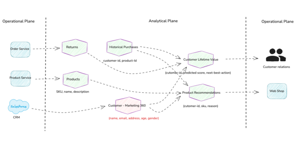
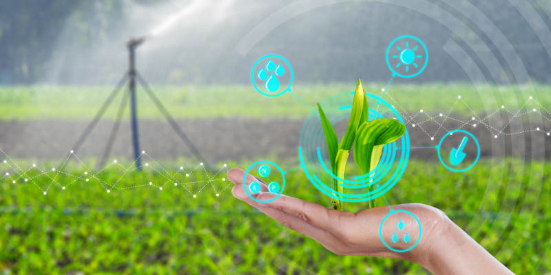
Debt-free farming: How satellite remote sensing is helping farmers avoid crop losses
Small and marginal farmers in India are empowered by satellite remote sensing, which helps minimise crop losses and build financial stability.
The agricultural sector of India is the backbone in terms of its economy and employment because, according to the report of the World Bank collection of development indicators in 2023, it employs more than 43.5% of the workforce and brings up to 18% of the national GDP (FAO).
Marginally sized farmers who engage in small plots of land, smaller than 5 acres, are unable to afford precision farming tools like IoT-based soil sensors and automatic weather stations. These devices can cost hundreds of dollars a year, which is a high price for farmers already making meager profits. As a result, although the technology is available, the value proposition typically does not make sense for these smaller operations.
However, the emergence of a promising solution is satellite remote sensing. This cost-effective, scalable, and flexible technology is revolutionising agriculture by enabling farmers to make sound decisions, avoid financial distress due to crop failure.
What is satellite remote sensing and how does it benefit small farmers?
Satellite remote sensing involves taking pictures of the Earth's surface using satellites equipped with specialised sensors. This technology gives you detailed information about several agricultural parameters, including soil moisture, vegetation health, and the weather. While this technology is convenient for large landowners, it is also useful for small scale farmers in managing plots as small as 0.25 acres (about 10,000 square feet).
Though satellite monitoring services tend to be more costly for large agriculture companies, the price of satellite monitoring services for smallholders is typically under 5 percent of total cultivation costs, at least. In addition, satellite data is also particularly scalable and accessible. Extensive areas are covered and deliver timely insights without needing on-ground sensors. This information can be obtained by farmers through mobile applications or SMS alerts without having to pay for expensive hardware or devices.
Why is satellite remote sensing crucial for Indian agriculture?
This technology has become essential because of multiple urgent challenges in the industry. Weather patterns with unpredictable shifts have become one of the main problems because they cause significant losses for crops. In 2023, the State of Karnataka suffered crop damages worth Rs 35,000 crore, which affected 4.8 million hectares because of dry conditions that reached severe levels. Another challenge is resource optimization.
Remote sensing technology proves vital for farm profitability because it allows for optimised water and fertiliser use, according to various studies, can reduce fertiliser costs by up to 30%. Satellite data enhances market participation by providing timely insights, which benefits farmers in their competitive market involvement. Through enhanced decision making, farmers gain both better crop quality and elevated yields, together with improved market preparedness.
Where and when can this technology be applied?
Satellite remote sensing particularly benefits areas with diverse agro-climatic conditions like India. Its use is appropriate and relevant throughout the crop cycle:
- Pre-Sowing: Soil moisture evaluation, land condition analysis, and soil nutrient testing together help determine the ideal planting days before sowing begins.
- Growth Period: The stage of Growth Period involves continuous crop assessment for health status and pest detection, together with nutrient requirement evaluation for targeted improvements.
- Pre-Harvest: Before harvest, the process includes yield projection, determining the proper harvest date through crop maturity evaluation tests, managing pests and diseases, and ensuring optimal irrigation water management.
How can farmers access and implement this technology?
Adopting satellite remote sensing involves several steps:
- Training and Education: Agricultural professionals require training that educates them about the interpretation of space-based information in combination with application methods for their operational farming activities. The training of farmers in satellite data interpretation must come from government agencies and non-profit organisations.
- Collaborative Platforms: The creation of cooperatives alongside farmer producer organizations (FPOs) enables joint satellite service access among farmers, which simultaneously decreases costs while sharing valuable information.
- Policy Support: Government bodies offering financial support through policy initiatives for digital agriculture reduce the financial costs faced by smallholders when they adopt these technologies.
Final thoughts
Small and marginal farmers in India are empowered by satellite remote sensing, which helps minimise crop losses and build financial stability. By delivering affordable agricultural insights—such as soil nutrient levels, fertilizer recommendations, and irrigation water management—this technology supports better decision-making and efficient resource use.
These insights not only improve productivity but also promote climate-resilient farming. With proper training and strong policy support, satellite remote sensing can play a vital role in achieving debt-free and sustainable agriculture across India.
(Sat Kumar Tomer is the co-founder and CEO of Satyukt Analytics.)
Edited by Jyoti Narayan