


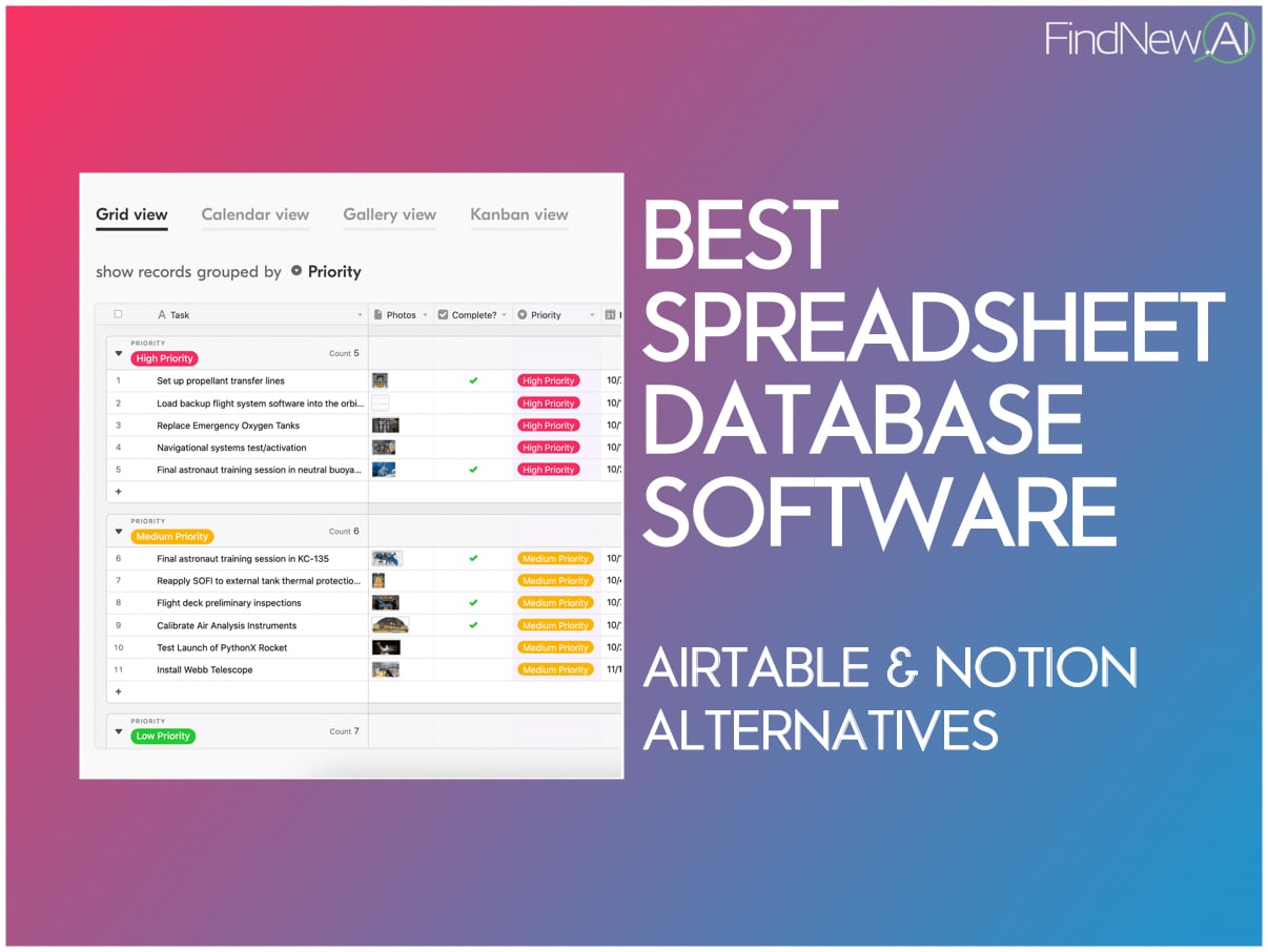


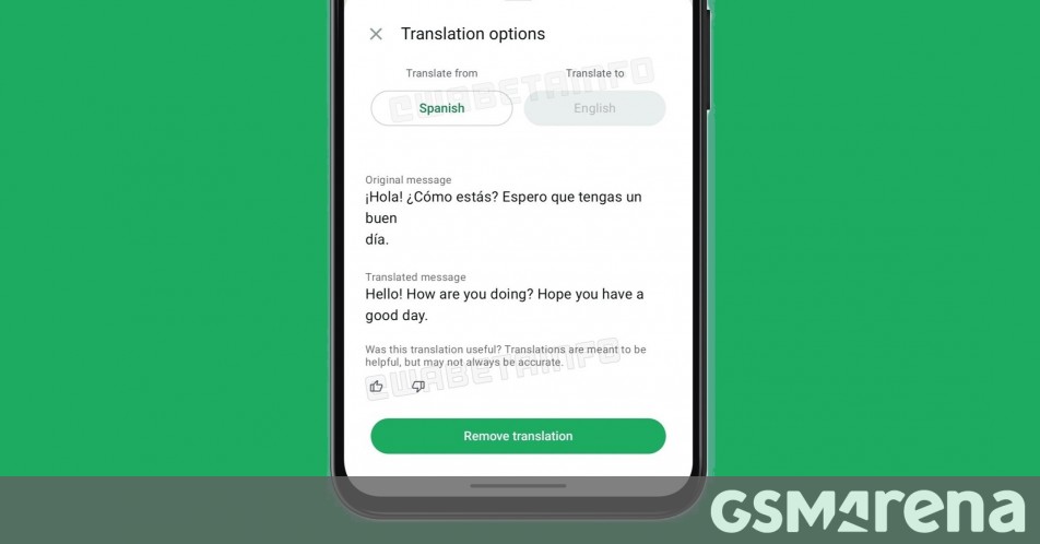
![[The AI Show Episode 144]: ChatGPT’s New Memory, Shopify CEO’s Leaked “AI First” Memo, Google Cloud Next Releases, o3 and o4-mini Coming Soon & Llama 4’s Rocky Launch](https://www.marketingaiinstitute.com/hubfs/ep%20144%20cover.png)


![Is this too much for a modular monolith system? [closed]](https://i.sstatic.net/pYL1nsfg.png)


_Andreas_Prott_Alamy.jpg?width=1280&auto=webp&quality=80&disable=upscale#)


![What features do you get with Gemini Advanced? [April 2025]](https://i0.wp.com/9to5google.com/wp-content/uploads/sites/4/2024/02/gemini-advanced-cover.jpg?resize=1200%2C628&quality=82&strip=all&ssl=1)


![Apple Shares Official Trailer for 'Long Way Home' Starring Ewan McGregor and Charley Boorman [Video]](https://www.iclarified.com/images/news/97069/97069/97069-640.jpg)
![Apple Watch Series 10 Back On Sale for $299! [Lowest Price Ever]](https://www.iclarified.com/images/news/96657/96657/96657-640.jpg)
![EU Postpones Apple App Store Fines Amid Tariff Negotiations [Report]](https://www.iclarified.com/images/news/97068/97068/97068-640.jpg)
![Apple Slips to Fifth in China's Smartphone Market with 9% Decline [Report]](https://www.iclarified.com/images/news/97065/97065/97065-640.jpg)


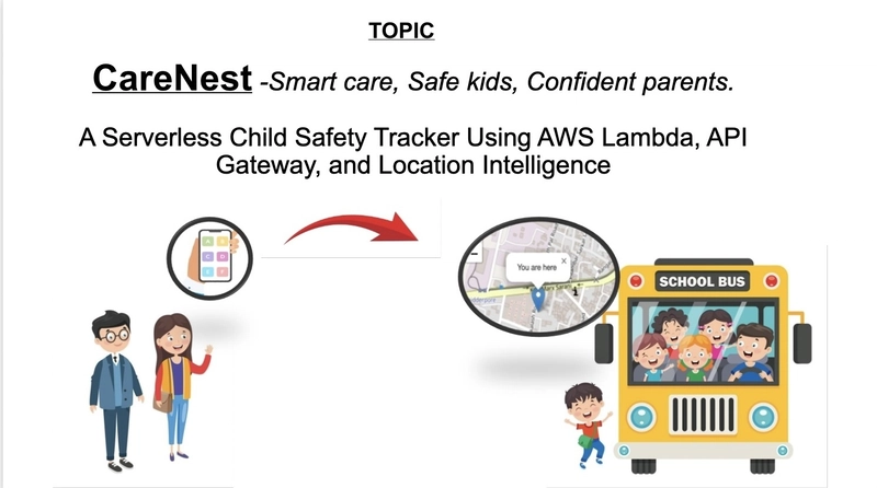
CareNest: A Serverless Child Safety Tracker Powered by AWS - Smart care, Safe kids, Confident parents.
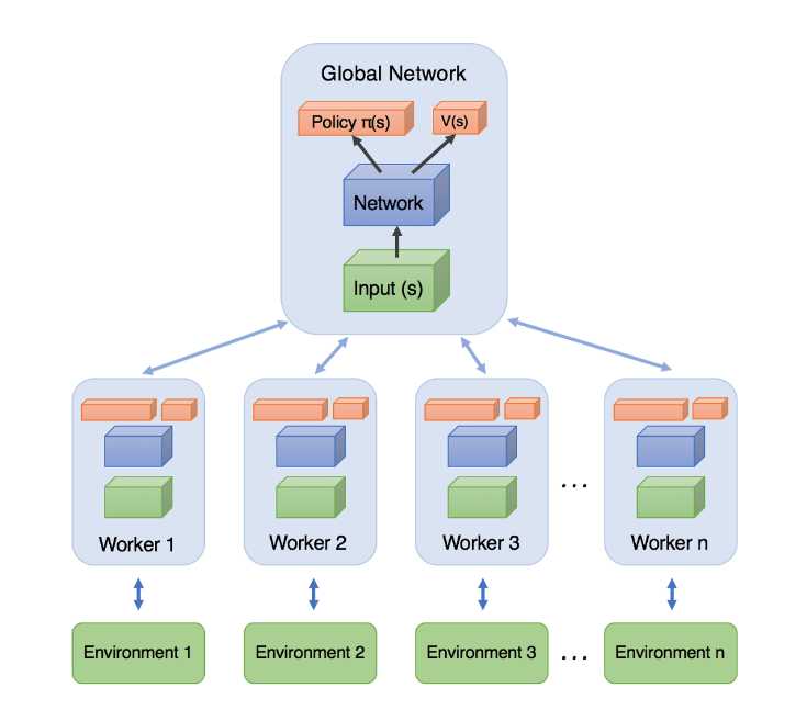
Problem Statement Children’s safety isn’t just a personal concern, it affects the mental well-being of parents globally. In India, a child goes missing every 8 minutes, according to the National Crime Records Bureau (NCRB). More than 47,000 children were reported missing recently, and 71.4% of them were minor girls. While location-tracking apps exist, most fail to offer real-time emergency alerting, crime mapping, or safe route guidance. There’s a clear gap for an application that combines live location tracking, instant panic alerts, and intelligent safety indicators — all in one. What is CareNest? CareNest is a browser-based child safety application designed to Track a child’s real-time location using the browser’s geolocation API and LeafletJS. Allow a child to trigger an emergency alert via a panic button. Identify poorly lit streets, safe zones, and nearby facilities like hospitals or police stations. Use AWS serverless services to process and deliver real-time alerts. Offer a lightweight, scalable, and cost-efficient solution using cloud-native architecture. AWS Architecture Here's how the components work together: Frontend (GitHub Pages)- A responsive UI built with HTML, CSS, JavaScript, and LeafletJS. Geolocation API-Tracks the child’s live coordinates from the browser. Amazon API Gateway Securely exposes backend endpoints to receive panic alert data. AWS Lambda (Node.js)-Processes the alert, fetches address using LocationIQ, and sends the message. LocationIQ API-Converts latitude/longitude into a readable address (reverse geocoding). Amazon SNS-Sends emergency alerts via SMS and email to registered contacts. CORS + HTTPS-Ensures secure, cross-origin requests from the frontend. Functionality Frontend: Built using HTML, JS, and LeafletJS, hosted on GitHub Location Tracking: Uses browser geolocation to track movement on the map. Panic Button: When clicked, sends coordinates to an API Gateway endpoint. AWS Lambda: Processes the request, fetches address using LocationIQ, and sends message via Amazon SNS. SNS: Sends emergency alert to a subscribed parent. Front end will display live location of the child, panic button and child profile. In the backend AWS Lambda is used for serverless function for emergency alert handling. Amazon API gateway is used to expose Lambda as secure HTTP endpoint. Amazon SNS is used to real time emergency alerts to registered contacts. LocationIQ API is used for reverse geocoding is used to convert latitude and longitude to human-readable address. GitHub Pages (Static Frontend) is used to host the live frontend of the application. CORS Configuration, HTTPS ensures secure data transmission and cross-origin request control. For Future Scope Government APIs / OpenStreetMap Crime, Light, Safety Data will be used for marking safe places, crimes, and light/dark streets. Advantages Lightweight and cost-effective due to serverless setup Near-instant emergency alerts via SNS Parent peace-of-mind with real-time tracking Can scale easily, no backend server to manage Fast and responsive Challenges & Learnings Faced CORS issues on API Gateway — fixed with proper OPTIONS method and headers. Understood how SNS topics and subscriptions work. Learned to use LeafletJS and geolocation together. Gained insights into serverless application design. Risk Zone Prediction with Machine Learning Battery Health Monitoring Native Mobile App with React Native Multi-Channel Alerts Integration

Problem Statement
Children’s safety isn’t just a personal concern, it affects the mental well-being of parents globally. In India, a child goes missing every 8 minutes, according to the National Crime Records Bureau (NCRB).
More than 47,000 children were reported missing recently, and 71.4% of them were minor girls. While location-tracking apps exist, most fail to offer real-time emergency alerting, crime mapping, or safe route guidance.
There’s a clear gap for an application that combines live location tracking, instant panic alerts, and intelligent safety indicators — all in one.
What is CareNest?
CareNest is a browser-based child safety application designed to
- Track a child’s real-time location using the browser’s geolocation API and LeafletJS.
- Allow a child to trigger an emergency alert via a panic button.
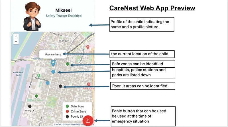
- Identify poorly lit streets, safe zones, and nearby facilities like hospitals or police stations.
- Use AWS serverless services to process and deliver real-time alerts.
- Offer a lightweight, scalable, and cost-efficient solution using cloud-native architecture.
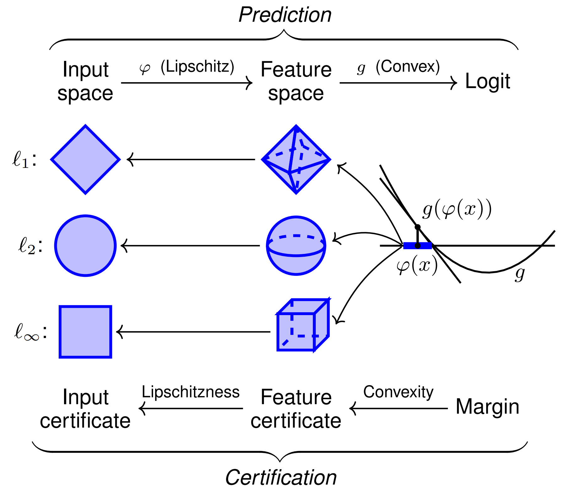
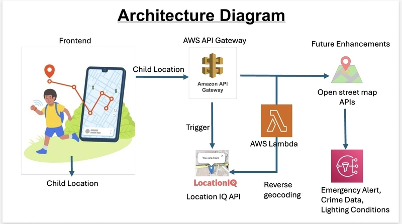
AWS Architecture
Here's how the components work together:
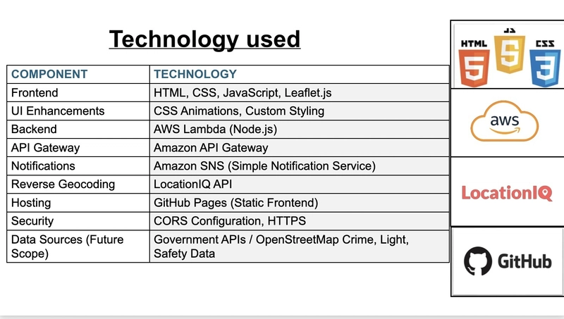
Frontend (GitHub Pages)- A responsive UI built with HTML, CSS, JavaScript, and LeafletJS.
Geolocation API-Tracks the child’s live coordinates from the browser.
Amazon API Gateway Securely exposes backend endpoints to receive panic alert data.
AWS Lambda (Node.js)-Processes the alert, fetches address using LocationIQ, and sends the message.
LocationIQ API-Converts latitude/longitude into a readable address (reverse geocoding).
Amazon SNS-Sends emergency alerts via SMS and email to registered contacts.
CORS + HTTPS-Ensures secure, cross-origin requests from the frontend.
Functionality
Frontend: Built using HTML, JS, and LeafletJS, hosted on GitHub
Location Tracking: Uses browser geolocation to track movement on the map.
Panic Button: When clicked, sends coordinates to an API Gateway endpoint.
AWS Lambda: Processes the request, fetches address using LocationIQ, and sends
message via Amazon SNS.
SNS: Sends emergency alert to a subscribed parent.
Front end will display live location of the child, panic button and child profile. In the backend AWS Lambda is used for serverless function for emergency alert handling. Amazon API gateway is used to expose Lambda as secure HTTP endpoint. Amazon SNS is used to real time emergency alerts to registered contacts. LocationIQ API is used for reverse geocoding is used to convert latitude and longitude to human-readable address. GitHub Pages (Static Frontend) is used to host the live frontend of the application. CORS Configuration, HTTPS ensures secure data transmission and cross-origin request control. For Future Scope Government APIs / OpenStreetMap Crime, Light, Safety Data will be used for marking safe places, crimes, and light/dark streets.
Advantages
Lightweight and cost-effective due to serverless setup
Near-instant emergency alerts via SNS
Parent peace-of-mind with real-time tracking
Can scale easily, no backend server to manage
Fast and responsive
Challenges & Learnings
Faced CORS issues on API Gateway — fixed with proper OPTIONS method and headers.
Understood how SNS topics and subscriptions work.
Learned to use LeafletJS and geolocation together.
Gained insights into serverless application design.
Risk Zone Prediction with Machine Learning
Battery Health Monitoring
Native Mobile App with React Native
Multi-Channel Alerts Integration