


![[The AI Show Episode 142]: ChatGPT’s New Image Generator, Studio Ghibli Craze and Backlash, Gemini 2.5, OpenAI Academy, 4o Updates, Vibe Marketing & xAI Acquires X](https://www.marketingaiinstitute.com/hubfs/ep%20142%20cover.png)


![From drop-out to software architect with Jason Lengstorf [Podcast #167]](https://cdn.hashnode.com/res/hashnode/image/upload/v1743796461357/f3d19cd7-e6f5-4d7c-8bfc-eb974bc8da68.png?#)


.png?#)


_Christophe_Coat_Alamy.jpg?#)
 (1).webp?#)


![Apple Considers Delaying Smart Home Hub Until 2026 [Gurman]](https://www.iclarified.com/images/news/96946/96946/96946-640.jpg)
![iPhone 17 Pro Won't Feature Two-Toned Back [Gurman]](https://www.iclarified.com/images/news/96944/96944/96944-640.jpg)
![Tariffs Threaten Apple's $999 iPhone Price Point in the U.S. [Gurman]](https://www.iclarified.com/images/news/96943/96943/96943-640.jpg)


How can GIS map in video management software platform to enhance video management?
When GIS maps integrated into a video management software platform, user can visualize and operate surveillance resources such as IP camera, NVR, CVR, access control devices etc directly on an interative map interface on VMS system. Set SVMSPro video management software platform for example. It has integrated Google GIS platform, which enables administrators and operators to visualize and operate critical resources—including IP cameras, NVRs, and CVRs etc—directly on an interactive Google Map interface. Key Functionalities: Device Geolocation & Visualization All managed devices by SVMS Pro---including IP camera, NVR, and CVR etc can be located on Google Maps by device’ longitude and latitude. Direct Map-Based Monitoring Live view or historical playback of any device channel directly from the map interface. Visualize real-time alarm notifications (e.g. motion detection, device offline detection, line-crossing detection) on map for instant incident response. Layered Data Visualization: Hierarchical map tree and device tree management for complex deployments. GIS map can also link with 2D flat map for multi-layered monitoring. 2D flat map can be directly located on GIS map. More about 2D flat map Integration: Locate and configure resources (cameras, alarm inputs, access control channels, hot zones) on 2D flat map. One camera position point on the 2D flat map can link with up to four different camera videos. It also supports alarm linked pop-up video on 2D flat map.
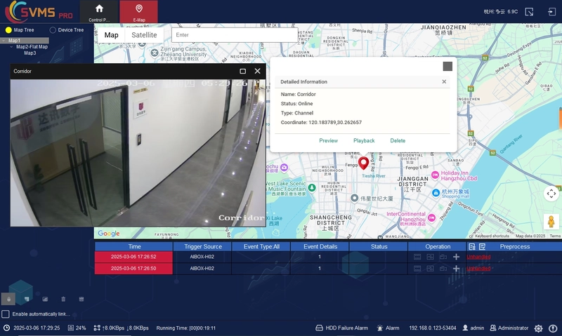
When GIS maps integrated into a video management software platform, user can visualize and operate surveillance resources such as IP camera, NVR, CVR, access control devices etc directly on an interative map interface on VMS system.
Set SVMSPro video management software platform for example. It has integrated Google GIS platform, which enables administrators and operators to visualize and operate critical resources—including IP cameras, NVRs, and CVRs etc—directly on an interactive Google Map interface.
Key Functionalities:
- Device Geolocation & Visualization
All managed devices by SVMS Pro---including IP camera, NVR, and CVR etc can be located on Google Maps by device’ longitude and latitude.
- Direct Map-Based Monitoring
- Live view or historical playback of any device channel directly from the map interface.
- Visualize real-time alarm notifications (e.g. motion detection, device offline detection, line-crossing detection) on map for instant incident response.
- Layered Data Visualization:
Hierarchical map tree and device tree management for complex deployments.
GIS map can also link with 2D flat map for multi-layered monitoring. 2D flat map can be directly located on GIS map.
More about 2D flat map Integration:
- Locate and configure resources (cameras, alarm inputs, access control channels, hot zones) on 2D flat map.
- One camera position point on the 2D flat map can link with up to four different camera videos.
- It also supports alarm linked pop-up video on 2D flat map.